Sunday, February 24, 2013

Thursday, February 21. A sad farewell to good friends and beautiful scenery


By 8:00 am the vans were loaded, and we headed back along the Apache Trail.  We made a brief stop at the Fish Creek hill where the road narrows before a hairpin turn and steep uphill section. The melting snows provided us with the unusual desert site of delicate waterfalls cascading down the cliff side.  


One van stopped at our Mesa motel for those who had left their cars there for the week and then continued up to Scottsdale where 4 of our participants would join another NAU program for a second week of hiking.  The second van took the rest of us to the Phoenix airport where we were catching our return flights.  It was an amazing week of beautiful and challenging hikes, and we all said our sad good-byes to our hiking friends and program coordinators.  As soon as we got home, we started searching our RS catalogues for our next adventure!

Wednesday, February 20. A relaxed day of ruins and videos.


We woke up this morning to gray skies and heavy rain.  After a very good breakfast of scrambled eggs and pancakes, Mike explained our alternative plans for day.  With wet trails and the prediction for snow, hiking wasn’t a good option.  Se we headed northeast on the Apache Trail, driving 16 miles on the very rough washboard surface until the pavement returned near the Theodore Roosevelt Dam.  Completed in 1911 and modified in 1989-1996, the 357 foot high dam impounds the Salt River and results in the very large Roosevelt Lake.  
Morning storm clouds over Apache Lake.

On the way to the Roosevelt Dam on the Apache Trail.

The Roosevelt Dam. 

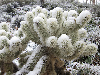
After a brief stop to admire the dam, we continued on to the Tonto National Monument with its well-preserved ancient cliff dwellings.  We watched a video about the dwellings and then followed the ranger on the short, steep paved trail to the lower ruins.  While he told us about the ruins, the snow began in earnest.  The ranger told us that this was the first time he had seen the trail covered in snow during his five years at the monument.  We hiked back down to the visitor center in the heavy snow, admiring the unusual sight of snow-covered cacti.  The rangers allowed us to eat on the carpeted floor of the visitor center, and then we drove to the Roosevelt Lake Visitor Center where we explored the displays and watched videos about the area.  


As we drove back to Apache Lake, we admired all the snow-covered mountains surrounding us.  The views from our balconies were very lovely.  


After another excellent dinner, this time of broiled trout filets, we had some time to comment on the excellent program and to thank Mike and Michael for their outstanding leadership.  We then had the evening to relax and pack our suitcases. 

Tuesday, February 19. A long, beautiful hike along the Reavis Ranch Trail


After a good fried egg, ham, and cheese sandwich for breakfast, we started out on our day’s adventures, with bright sunshine and blue skies.  The temperatures have been in the 70’s each day making for beautiful hiking weather, but also warm enough that many of us needed the full two liters of water that we were told to carry.  We drove back a few miles along the Apache Trail and then drove 3 miles up a narrower dirt road to the trailhead.  This hike, through the Superstition Wilderness Area and the Tonto National Forest, included a gradual but steady climb through grassy rolling hills on a sandy and in places rocky trail.  Along the way Mike pointed out more facts about the local plants and showed us a grinding stone used by the Native Americans that had lived in this area.  After 4.5 miles and 1000 feet of vertical gain, we reached our lunch stop on the saddle below Castle Dome.  Two of our hikers continued for about 20 minutes on the trail towards Windy Pass, hiking through some of the remaining snow on the north side of Castle Dome.  We all enjoyed hiking at our own speed back to our waiting vans.  At times I was completely alone in the quiet of the wilderness, a welcomed time that contrasts so with our busy and often noisy lives at home. 

Climbing above Apache Lake
Castle Dome, the day's destination. 


Enjoying lunch at the saddle.
A Native American grinding stone.


            Following a delicious dinner that included a half of a baked chicken, we met with Mike for about 90 minutes of human and natural history of the area, including stories about Reavis, the hermit-like rancher for whom today’s trail was named.  

Monday, February 18. Heading to Apache Lake Resort


Today was planned with a shorter, easier hike, to give our tired feet a chance to recover and also because of the fairly long drive.  However, our guides altered the hiking schedule because of the prediction of wet and windy weather on Wednesday.  We drove east on US 60, and then in Apache Junction we turned north on the Apache Trail.  We stopped briefly at the visitor center at the Lost Dutchman State Park so that we could buy maps, postcards, or t-shirts.  Our group then split into two parts, with Michael’s van parking a few miles farther at the First Water Trailhead and Mike’s van continuing to Canyon Lake.  As Mike explained our hike, this would be the “Key Pass” hike, with the two groups hiking the trail in opposite directions and exchanging van keys at the half way point.  We were in Mike’s van so we headed northeast past Tortilla Flat.  Soon the paved surface turned to a very rutted dirt road.  The dirt road continues for about 30 miles, winding its way to the Roosevelt Dam and passing Apache Lake Resort at about the halfway point.  We were very glad to have experienced drivers on this historic road.  Our van parked at Canyon Lake and started hiking up the Boulder Canyon Trail.  As we climbed up into the hills, we immediately had amazing views of Canyon Lake and the very rocky canyons and valleys.  After a long uphill climb we reached the ridge and had views of Weaver’s needle in the distance.  We met Michael’s group (and exchanged van keys) just after we rocked hopped across La Barge Creek and before our lunch stop.  We had lunch in a scenic spot near a creek.  Our lunches were packed each day at the local grocery store and included a large sandwich, chips, fruit and desert – definitely enough food to give us energy for finishing our hike.  During the rest stop, Mike demonstrated his skill of bandaging blistered toes with the skillful use of duct tape.  After lunch we turned onto the Second Water Trail.  We climbed out of the creek area and entered a beautiful flat section named the “Garden Valley.”  The numerous Cholla cactus trees made this section appear almost like a fruit orchard and provided a welcome contrast to the rocky sections of the trail.  Our long hike ended at the First Water Trailhead, and we drove the remaining 15 miles of rough road to Apache Lake.  Dinner was delayed until 6:30 so that we could all have a chance to check into our rooms and clean up at least a little bit. 
Hiking above Canyon Lake.
Rock cairns help mark the trail.

Weaver's Needle in the distance.

The Garden Valley


Calling Apache Lake a “resort” is probably a stretch, but the motel type rooms were reasonably clean, large, and comfortable, with balconies overlooking the beautiful lake.  We ate breakfasts and dinners in the resort restaurant, and they also packed us a substantial sack lunch for the next two days.  Another advantage of the location is the bar where we enjoyed gathering before dinner.  Tonight’s satisfactory dinner was a salad, followed by pork chops with potatoes and veggies, plus desert.  No evening program so that we could unpack and get our tired bodies to bed a little earlier.


View of Apache Lake at sunrise from our patio.


Sunday, February 17. An amazing hike in the Superstitions!


 This morning we drove east for about 30 minutes to Gold Canyon and then drove north on a dirt road for several miles, ending in the parking lot for the Peralta Cave Trail Loop, on the southern side of the Superstitions.  We followed the very rocky Peralta Trail for about 2.5 miles up Peralta Canyon as it climbed 1300 feet to the Fremont Saddle.  The trail begins in a desert riparian landscape with beautiful saguaro cacti on the rocky walls of the canyon.  At some places on the trail we actually had some shade as we passed through groves of small trees and shrubs.  We had some good natured joking as our participants from “greener” states questioned our guide's descriptions of these rather short desert plants as "trees."  After some rocky, steep switchbacks, we arrived at the saddle where amazing views of Weaver’s Needle suddenly appear.  At the end of a short hike out the Weavers Needle Overlook Ridge, we ate lunch looking at the beautiful views of the surrounding cliffs and canyons. 

Starting up the trail.
Beautiful rock formations


Weaver's Needle from the saddle.

            We returned via the Cave Trail, described in the program literature as an “off the beaten track route . . . with some steep sections where you will learn to trust your boots.”  For David and I this trail was a highlight of the week, as we have hiked the Peralta Trail on our own but have never attempted this return route.  With words in our book of trail descriptions like “slick steep rock face,” ‘allow extra time for route finding,” and “be extra careful when shimmying down here,” we have not wanted to venture here on our own.  But Mike’s guiding and encouragement were fantastic, and we all descended back to the waiting vans without major mishaps. 
Starting down the Cave Trail
We learn to "trust our boots."


That's the steep slope that we descended, after coming
around the  base of the knob.
 For dinner we returned to the Friday night restaurant and then had a free evening to pack and prepare for the next part of our adventure.

Saturday, February 16. Our first day of hiking


 Our 7:00 am breakfast was in the hotel where we could choose foods from the hotel buffet, supplemented by bananas provided by Michael.  Food was OK and included hard-boiled eggs plus the usual hotel buffet choices.  By 8:15 we were in the two vans, headed for our first hike.  A short drive took us to the Usery Mountain Regional Park and the Pass Mountain Trail.  David and I had hiked this trail on our own a couple of years ago, but it was fun to revisit the area and learn so many facts from Mike about the geology and desert plants.  The loop hike was about 7.5 miles in length with about 750 feet of elevation gain.  The trail is sandy in parts and very rocky in other sections and included a couple of long gradual inclines plus one set of steep switchbacks coming down from the saddle where we ate our lunch.  We could see the Superstition Mountains in the distance.  This was an excellent introductory hike and helped to wake up our hiking legs!


Mike "playing music" on the cactus.

David and Ellie enjoying the view!

"Four Peaks" and the Superstitions in the distance.

          We ate dinner at a local Mexican restaurant and then enjoyed a great evening program.  An expert on local animal life brought live examples of his favorite desert inhabitants – snake, lizard, scorpion, and tarantula.


Friday, February 15. Joining our RS group


This morning we joined my friend Andrea for breakfast.  Andrea and I have taken two RS trips together, including the Lincoln program in September that I wrote about in this blog.  After breakfast, we drove to Scottsdale and toured Taliesin West, a 600-acre complex that was designed and built by Frank Lloyd Wright.  The buildings are very beautiful and also quite different from the other FLW homes that I have toured.  If you have time while in the Phoenix area, I recommend taking the tour of the site.  You can buy advance tickets on line. 


            In the late afternoon we met our group and the two program coordinators/guides at the motel.  The motel is located within easy walking distance of a variety of stores, including a drugstore where one can purchase forgotten supplies such as sunscreen and moleskin.  We were given a choice of six different entries for dinner at a restaurant just a short van ride away.  After a very good dinner, we gathered in one of the motel meeting rooms for the usual introductions and orientation.  Mike Young is a well-known coordinator who leads many of the Northern Arizona University RS programs.  He is so enthusiastic and knowledgeable with a great sense of humor.  The second coordinator is also Michael, one of the employees at NAU who sometimes gets out of the office to help guide the trips.  Both Michael’s were fantastic as our guides for the week.
            The 17 participants range in age from 55 to 75 and come from many states and Canada:  Massachusetts, Ohio, Alberta, Oregon, Georgia, Maryland, British Columbia, Michigan, and Washington State.  This seems like a great group, and we are already having fun together.  

Thursday, February 14. Arrival in Phoenix.


David and Ellie flew to Phoenix today and will join our Road Scholar hiking group tomorrow afternoon for program #19723, Hiking Arizona's Sonoran Desert:  Exploring the Superstition Mountains.   We are staying in Mesa, east of Phoenix and only about 15 minutes from the airport, at the same hotel that the RS program will use for the first 3 nights.  We are excited to start another hiking adventure!